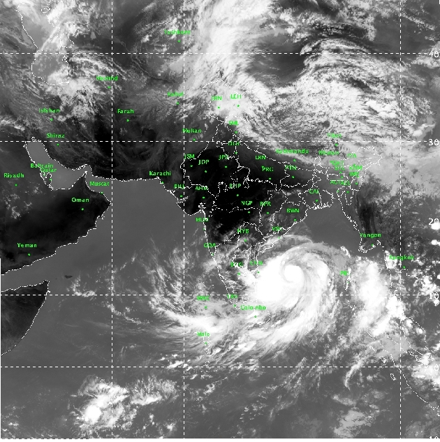
The Very Severe Cyclonic Storm “Fani” over Southeast and adjoining Southwest Bay of Bengal moved north-northwestwards with a speed of about 23 kmph in last six hours and lay centred about 830 km nearly south of Puri and 670 km south-southeast of Vishakhapatnam and about 680 km northeast of Trincomalee in Sri Lanka.
It is very likely to intensify further into an Extremely Severe Cyclonic Storm during next 12 hours and move northwestwards till May 1 evening and thereafter recurve north-northeastwards and reach Odisha Coast by May 3 afternoon with maximum sustained wind of speed 170-180 gusting to 200 kmph.
Forecast and warnings for Odisha
Light to moderate rainfall at many places with heavy to very heavy rainfall very likely over the districts of Gajapati, Ganjam , Puri, Khordha of south coastal Odisha and Rayagada and Kandhamal districts of south Interior Odisha on May 2.
It is likely to increase with rainfall at most places with heavy to very heavy rainfall at a few places with extremely heavy falls at isolated places over the districts of coastal Odisha & adjoining Kandhamal,Rayagada, Boudh,Angul, Dhenkanal, Keonjhar, Mayurbhanj, Sambalpur and Deogarh districts of interior Odisha on May and over Mayurbhanj, Keonjhar and Dhenkanal the districts of north Odisha on May 4.
Wind Warning:
Gale wind speed reaching 135-145 kmph gusting to 160 kmph is prevailing over Southeast & adjoining Southwest Bay of Bengal. It is very likely to increase gradually becoming 165-175 kmph gusting to 195 kmph over Westcentral & adjoining Southwest Bay of Bengal off north Tamil Nadu, Puducherry and south Andhra Pradesh Coast from April 30 night onwards.
Also Read http://- Cyclone Fani: Centre Releases Advance Fund Worth Rs 341 Crore To Odisha
Squally wind speed reaching 40-50 kmph gusting to 60 kmph is very likely to commence along and off Odisha Coasts from May 2 and very likely to become gale wind, speed reaching 60-70 kmph gusting to 85 kmph from 3rd May morning and become 170-180 gusting 200 kmph over Odisha Coast by May 3 evening.
Sea Condition
The sea condition is phenomenal over southwest and adjoining westcentral Bay of Bengal, off north Tamilnadu, Puducherry and south Andhra Pradesh Coasts from today morning and is very likely to become phenomenal over westcentral Bay of Bengal during 1-3 May 2019 and over Northwest Bay of Bengal during May 2 to 4.
Sea conditions very likely to be rough to very rough along and off Odisha and West Bengal Coasts on May 2 and become phenomenal on May 3.
Fishermen Warnings
Fishermen, those who are out in deep sea areas are advised to return to coast by 1st May Morning.
The fishermen are advised not to venture into deep sea areas of Southeast Bay of Bengal & adjoining Equatorial Indian Ocean, Southwest Bay of Bengal and off Sri Lanka coast on April 30; Southwest and adjoining westcentral Bay of Bengal, along and off Sri Lanka, Puducherry, Tamil Nadu and south Andhra Pradesh coasts till May 1, westcentral Bay of Bengal, along and off north Andhra Pradesh Coast during May 1-3 and northwest and adjoining Westcentral Bay of Bengal along and off Odisha and West Bengal coasts from May 2 onwards.