Bhubaneswar, October 9, 2018: The deep depression over west-central Bay of Bengal intensified into a Cyclonic Storm ‘Titli’ on Tuesday afternoon. It is very likely to intensify further into a severe cyclonic storm during next 24 hours and cross Odisha and adjoining north Andhra Pradesh coasts between Gopalpur and Kalingapatnam around Thursday morning, said India Meteorological Department (IMD).
“The deep depression over west-central Bay of Bengal moved west-north-westwards with a speed of eight kmph during past six hours and intensified into a Cyclonic Storm ‘Titli’ and lay cantered at 11.30 am Tuesday over west-central Bay of Bengal near latitude 14.8°N and longitude 86.7°E, about 530 km southeast of Gopalpur (Odisha) and 480 km east-southeast of Kalingapatnam (Andhra Pradesh),” it said.
“It is very likely to move west-north-westwards for some more time, then north-westwards and cross Odisha and adjoining north Andhra Pradesh coasts between Gopalpur and Kalingapatnam around morning of October 11,” it predicted
Thereafter, it is very likely to re-curve north-eastwards, move towards Gangetic West Bengal across coastal Odisha and weaken gradually, it warned.
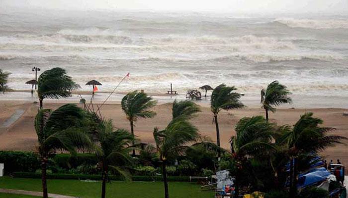
Under its impact squally wind speed reaching 45-55 kmph gusting to 65 kmph is very likely to commence along and off Odisha coast from Tuesday night which is very likely to increase gradually becoming 100-110 kmph gusting to 125 kmph from Wednesday evening onwards along and off south Odisha coast and 65-75 kmph gusting to 85 kmph along and off north Odisha coast, the IMD warned.
It also issued storm surge warning stating that storm surge of height of about 0.5 meter above astronomical tide is very likely inundate low laying areas of Ganjam, Khurda and Puri districts during the time of landfall on Thursday morning.
It also expected damage over the districts of Gajapati, Ganjam, Khurda, Nayagarh and Puri districts.
While the sea condition remained rough to very rough over central and adjoining north Bay of Bengal today, it warned of very rough to high in the sea condition on Wednesday and Thursday.
The IMD also cautioned the State Government against possible floods in view of the heavy rainfall across the State during the period.
Meanwhile, the Government issued alert to all districts, particularly the districts of coastal region, to deal with the situation. The district collectors have been asked to remain alert and make necessary arrangements to evacuate people living in the low-lying areas.
Deputy Special Relief Commissioner Prabhat Kumar Mohapatra informed that around 300 motor boats have been put in place to assist in rescue operation as there is likelihood of flood situation due to possibility of heavy rains till Thursday.
All the cyclone and flood shelters have also been kept in a state of preparedness, he added. Meanwhile, at least 14 districts were asked to be on high alert from Thursday morning to Friday morning.
The districts are Kalahandi, Boudh, Kandhamal, Nayagarh, Cuttack, Khurda, Dhenkanal, Jajpur, Bhadrak, Gajapati, Ganjam, Puri, Jagatsinghpur and Kendrapara. Collectors of these districts have been asked to be on high alert from 8.30 am on Thursday to 8.30 am on Friday to face the ensuing situation.